Niantic Spatial launched two products in April that represent a fundamental shift in how the company thinks about its technology. Scaniverse is an integrated platform for capturing physical spaces and generating 3D models. VPS 2.0 is a visual positioning system that delivers near-centimeter accuracy in mapped environments. Together, they form an infrastructure layer that could underpin the next generation of AR applications, autonomous systems, and spatial computing platforms.
EnterpriseApril 15, 2026
The Company Behind Pokemon GO Just Launched the Infrastructure Layer for AR
By Sam Whitfield
Contributing Writer, VR.org
Advertisement
The technology is built on a dataset that most people helped create without realizing it.

30 billion images from Pokemon GO
When millions of Pokemon GO players walked around their neighborhoods pointing their phones at landmarks, parks, and buildings, Niantic was collecting posed imagery data. Over the years, that dataset grew to over 30 billion geolocated images covering locations around the world. Niantic Spatial, which spun out as an independent company in May 2025 after Scopely acquired Niantic's licensed games division for $3.5 billion, retained that dataset and built its enterprise platform on top of it.
The company describes the underlying technology as a Large Geospatial Model, drawing a deliberate parallel to the large language models that power modern AI. Where LLMs process text to understand language patterns, Niantic's LGM processes spatial imagery to understand physical environments. The model can recognize surfaces, structures, and spatial relationships, then match real-time camera input against its maps for precise positioning.
What VPS 2.0 actually does
Visual Positioning System 2.0 provides 6DoF (six degrees of freedom) localization with near-centimeter accuracy in mapped environments. In practical terms, that means a device can determine exactly where it is and which direction it is facing within a physical space, with precision that GPS cannot match.
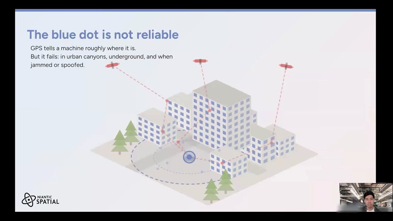
The system works at a basic level globally without prior mapping. In locations that have been captured through Scaniverse, it transitions to higher-precision mode. Over one million locations are already live and ready for use. The technology functions in environments where GPS is unreliable or unavailable: parking structures, dense urban corridors, indoor facilities, and underground spaces.
This addresses a real gap in the market. GPS accuracy degrades significantly in urban canyons and fails entirely indoors. For AR applications that need to anchor digital content to specific physical locations, that limitation has been a fundamental constraint. VPS 2.0 removes it for any mapped location.
Enterprise applications
Niantic Spatial is targeting four primary business categories with the platform. Spatial planning and design allows companies to present physical locations in full 3D complexity for architectural review, retail layout optimization, and facility planning. Warehousing and logistics uses the mapping data to optimize storage configurations and delivery routing. Entertainment and engagement covers digital overlays at physical venues for events, tourism, and retail experiences. Remote collaboration enables teams across locations to work together within shared spatial models.
The applications extend beyond traditional AR. Autonomous delivery robots can use VPS for navigation in environments where GPS is insufficient. Drones can operate with precision guidance without satellite dependency. Advanced driver assistance systems gain lane-level positioning accuracy in urban environments. These are not theoretical use cases. Niantic Spatial is actively pursuing partnerships with robotics companies and autonomous vehicle developers.

Developer access
NSDK 4.0, the company's developer toolkit, became generally available in April with support for Swift, Unity, and native Android development. ROS 2 support for robotics applications is available in early access. Scaniverse itself works with consumer smartphones and off-the-shelf 360-degree cameras, which means businesses do not need specialized equipment to start mapping their environments.
The company was funded with $250 million in capital following the Scopely separation and is led by John Hanke (CEO), Brian McClendon (CTO, formerly of Google Maps), and Thomas Gewecke (COO). That leadership team combines deep expertise in mapping, gaming, and media, which reflects the platform's positioning at the intersection of all three.
The market context
Niantic Spatial's pitch centers on mapping what the company calls "the 80% of the economy AI cannot see." Current AI systems rely heavily on text and image data from the internet. Physical environments, the spaces where most economic activity actually happens, remain largely undigitized. The enterprise AR and spatial computing market is projected to reach $280 billion by 2028, and infrastructure platforms like Niantic Spatial are positioning themselves as the foundational layer that other applications build on top of.
Whether Niantic Spatial captures a meaningful share of that market depends on developer adoption and enterprise deployment velocity. But the underlying asset, 30 billion geolocated images and a positioning system that works where GPS does not, is a genuine competitive advantage. No other company has that dataset, and no other company has the consumer-facing gaming platform to keep expanding it.
Advertisement